CKC has various geophysical exploration technologies that are nondestructive inspection methods used as a means to shed light on underground structures.
We also conduct various types of logging using boreholes to take measurements of structures and their surroundings.
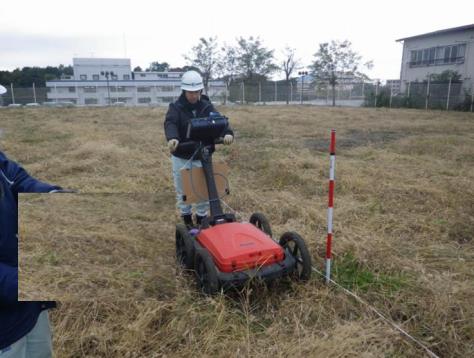
Ground-penetrating radar surveys
This method for underground exploration involves capturing electromagnetic waves reflected from borders with differing electrical properties. With this, borders with differing electrical properties can ascertained; this may include voids, buried objects, stratum boundaries, cracks and fault fractures, and the upper surfaces of structures and waste matter. In particular, since this radar reacts well to metal and hollow spaces, it is often used in void surveys to detect buried objects, pipes, and bomb shelters.
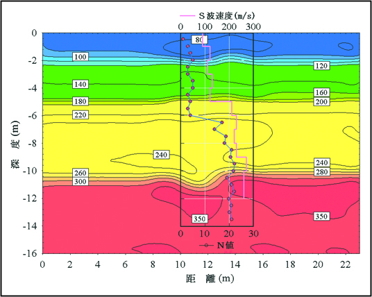
High-density surface wave surveys
For this exploration method, the ground is artificially vibrated and the phase velocity of surfaces waves is determined from waveform data measured by multiple geophones placed on the ground surface. From this phase velocity curve, the S-wave velocity structure is estimated using an inverse analysis method. With this, a two-dimensional S-wave velocity structure can be obtained. In addition to evaluating ground conditions using the S-wave velocity structure, it is also used as basic data for liquefaction determinations.
Microtremor array surveys
This method is used to estimate the S-wave velocity structure of array values as a one-dimensional structure, by analyzing data obtained from a seismograph that simultaneously records microtremors generated naturally or artificially. Depending on the size of the array, S-wave velocity structures of tens of meters to several thousand meters can be obtained. These S-wave velocity structures are used as basic data for creating seismic response and simulated earthquake motion.
Winner of the 2005 Society of Exploration Geophysicists of Japan Award